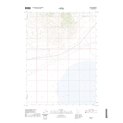
2023 Map of Bovine
USGS Topo · Published 2023About this map
Bovine Mountains anchor the northern reaches of this map, their high ridges and deep contours giving way to the expansive dry basins of western Box Elder County. This modern survey illustrates a landscape defined by its historic and functional transit routes, most notably the Emigrant Trail Rd tracing the northwest corner. The presence of water remains a critical landmark in this arid environment, represented here by Bull Springs in the southeastern quadrant. Access through the high country is facilitated by specialized tracks like the Tower Access Rd and Devil's Playground Rd, while the southern flats are skirted by the Pigeon Mountain Loop, reflecting the contemporary management of this vast open range.
Find a feature on this map
7 named features on this map. Tap any name to fly to it.
Don’t see what you’re looking for? This feature index may not catch every label — zoom into the map to look around manually.
Map Details
Editions of this 2023 Bovine Map
This is the sole edition of this map. No revisions or reprints were ever made.
Other maps of this area

1954 · Brigham City
USGS Topo · 1:250,000

1958 · Brigham City
USGS Topo · 1:250,000

1962 · Brigham City
USGS Topo · 1:250,000

1967 · Pigeon Mountain
USGS Topo · 1:24,000

1967 · Lucin NE
USGS Topo · 1:24,000

1971 · Prohibition Spring
USGS Topo · 1:24,000

1971 · Emigrant Pass
USGS Topo · 1:24,000
1971 · Rocky Pass Peak
USGS Topo · 1:24,000

1983 · Jackson
USGS Topo · 1:24,000

1983 · Bovine SE
USGS Topo · 1:24,000