
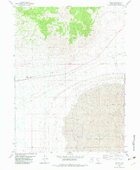
1983 Map of Jackson
USGS Topo · Published 1983About this map
Southern Pacific tracks cut a straight horizontal line across this arid stretch of Box Elder County, providing a vital transportation corridor through the Great Salt Lake Desert. Near the eastern edge of the quadrangle lies the settlement of Jackson, situated where the railroad meets the open expanse of Mud Flat. This 1983 orthophotomosaic, based on aerial photography from the mid-1970s, reveals the sparse infrastructure of the region, including several sections of Jeep Trail and areas marked Private. The terrain is defined by the stark contrast between the level alkaline basins and the prominent elevations of Pigeon Mountain and the Little Pigeon Hills. A singular Spring provides one of the few water sources in this remote landscape, highlighting the geographical challenges faced by those maintaining the rail lines and regional survey routes during this era.
Find a feature on this map
8 named features on this map. Tap any name to fly to it.
Don’t see what you’re looking for? This feature index may not catch every label — zoom into the map to look around manually.
Map Details
Editions of this 1983 Jackson Map
This is the sole edition of this map. No revisions or reprints were ever made.
Other maps of this area

1954 · Brigham City
USGS Topo · 1:250,000

1958 · Brigham City
USGS Topo · 1:250,000

1962 · Brigham City
USGS Topo · 1:250,000

1967 · Pigeon Mountain
USGS Topo · 1:24,000

1967 · Lucin NE
USGS Topo · 1:24,000

1967 · Lemay Island
USGS Topo · 1:24,000

1983 · Bovine SE
USGS Topo · 1:24,000

1983 · Terrace Mountain West
USGS Topo · 1:24,000

1983 · Lucin 4 NE
USGS Topo · 1:24,000
1983 · Bovine
USGS Topo · 1:24,000