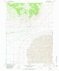
1983 Map of Bovine
USGS Topo · Published 1983About this map
Bovine Mountains dominate the northern horizon of this high-desert landscape in Box Elder County, where the terrain drops sharply into the expansive Mud Flat that covers the southern half of the sheet. The small settlement of Bovine sits at the center of a network of unimproved roads and a Jeep Trail, serving as a remote outpost in a region defined by its sparse water sources like Bull Springs and a lone Well. This 1983 survey captures a quiet era of land use, where technical infrastructure like a Radio Tower and Radio Facility stands alongside basic excavations such as a Gravel Pit and a natural Cave. The map illustrates the stark contrast between the steep, shaded slopes of the mountains and the perfectly level, featureless expanse of the flats below.
Find a feature on this map
12 named features on this map. Tap any name to fly to it.
Don’t see what you’re looking for? This feature index may not catch every label — zoom into the map to look around manually.
Map Details
Editions of this 1983 Bovine Map
This is the sole edition of this map. No revisions or reprints were ever made.
Other maps of this area

1954 · Brigham City
USGS Topo · 1:250,000

1958 · Brigham City
USGS Topo · 1:250,000

1962 · Brigham City
USGS Topo · 1:250,000

1967 · Pigeon Mountain
USGS Topo · 1:24,000

1967 · Lucin NE
USGS Topo · 1:24,000

1971 · Prohibition Spring
USGS Topo · 1:24,000

1971 · Emigrant Pass
USGS Topo · 1:24,000
1971 · Rocky Pass Peak
USGS Topo · 1:24,000

1983 · Jackson
USGS Topo · 1:24,000

1983 · Bovine SE
USGS Topo · 1:24,000