
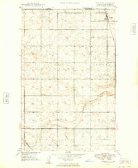
1949 Map of Bowbells
USGS Topo · Published 1949About this map
The railroad junction at Bowbells serves as the focal point of this 1940s landscape, where the Great Northern and Minneapolis St Paul and Sault Ste Marie rail lines converge. The town site is flanked by Bowbells Cem and St Joseph Cem, while the surrounding rural townships of Minnesota, Bowbells, and Denmark are dotted with landmarks of early 20th-century life, including School No 1 and School No 2.
Find a feature on this map
27 named features on this map. Tap any name to fly to it.
Don’t see what you’re looking for? This feature index may not catch every label — zoom into the map to look around manually.
Map Details
Editions of this 1949 Bowbells Map
This is the sole edition of this map. No revisions or reprints were ever made.
Other maps of this area

1947 · Bowbells NW
USGS Topo · 1:24,000

1947 · Bowbells
USGS Topo · 1:24,000

1948 · Kenmare
USGS Topo · 1:24,000

1948 · Coteau
USGS Topo · 1:24,000

1948 · Vanville NE
USGS Topo · 1:24,000

1949 · Bowbells SE
USGS Topo · 1:24,000

1949 · Bowbells NW
USGS Topo · 1:24,000

1949 · Niobe
USGS Topo · 1:24,000

1949 · Bowbells NE
USGS Topo · 1:24,000
1949 · Northgate
USGS Topo · 1:24,000