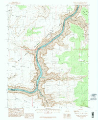
1987 Map of Bowdie Canyon West
USGS Topo · Published 1987About this map
Lake Powell and the Colorado River dominate this desert landscape where the borders of Garfield and San Juan counties meet. The map documents the intricate geography of the Glen Canyon National Recreation Area during the 1980s, showcasing the dramatic transition from high plateaus like Dry Mesa and Middle Point down into deep-cut gorges. Geologic and topographical details are prominent, from the sheer drops at Tar Cliff and Fault Point to the expansive Andy Miller Flats. Named water sources such as Cove Spring and Freddies Cistern hint at the survival necessities in this arid environment. The map also traces narrow tributaries like Dark Canyon and Bowdie Canyon, providing a technical look at the drainage patterns that define the Cataract Canyon reach before it enters the main reservoir of Glen Canyon.
Find a feature on this map
20 named features on this map. Tap any name to fly to it.
Don’t see what you’re looking for? This feature index may not catch every label — zoom into the map to look around manually.
Map Details
Editions of this 1987 Bowdie Canyon West Map
3 editions found
Other maps of this area

1885 · San Rafael
USGS Topo · 1:250,000

1886 · Henry Mountains
USGS Topo · 1:250,000

1892 · Henry Mountains
USGS Topo · 1:250,000

1952 · Mouth of Dark Canyon
USGS Topo · 1:62,500

1952 · Hite
USGS Topo · 1:62,500

1953 · Orange Cliffs 3 SE
USGS Topo · 1:24,000

1953 · Orange Cliffs 4 SW
USGS Topo · 1:24,000

1953 · Fiddler Butte
USGS Topo · 1:62,500

1953 · Orange Cliffs
USGS Topo · 1:62,500
1954 · White Canyon 1 NE
USGS Topo · 1:24,000