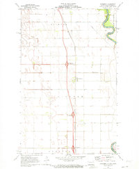
1971 Map of Bowesmont
USGS Topo · Published 1973About this map
Bowesmont sits at the heart of this Red River Valley landscape, where the transition from traditional river-bound transport to modern interstate travel is clearly visible. The North Red River and Red River meander along the eastern border, marking the boundary between Pembina and Kittson counties. This 1970s survey illustrates a landscape meticulously organized by an extensive drainage system, including County Ditch No 6 and County Ditch No 5, which supports the agricultural productivity of Joliette and Lincoln townships. The arrival of the interstate era is marked by the Bowesmont Interchange and Lincoln Interchange, providing high-speed transit that parallels the older Burlington Northern railroad line. To the south, the small settlement of Pittsburg appears near the border of Drayton township, and a prominent Radio Tower stands as a contemporary landmark in an otherwise flat, open expanse.
Find a feature on this map
21 named features on this map. Tap any name to fly to it.
Don’t see what you’re looking for? This feature index may not catch every label — zoom into the map to look around manually.
Map Details
Editions of this 1971 Bowesmont Map
2 editions found
Other maps of this area

1939 · Drayton
USGS Topo · 1:62,500

1939 · Glasston
USGS Topo · 1:62,500

1939 · Pembina
USGS Topo · 1:62,500

1941 · Drayton
USGS Topo · 1:62,500

1941 · Glasston
USGS Topo · 1:62,500

1941 · Bathgate
USGS Topo · 1:62,500

1941 · Pembina
USGS Topo · 1:62,500

1952 · Thief River Falls
USGS Topo · 1:250,000

1956 · Thief River Falls
USGS Topo · 1:250,000

1957 · Thief River Falls
USGS Topo · 1:250,000