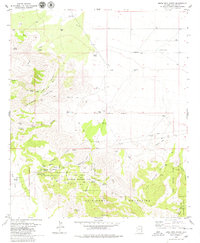
1979 Map of Bowie Mtn North
USGS Topo · Published 1979About this map
Fort Bowie National Historic Site anchors this survey of a critical desert corridor, preserving the Fort Bowie Ruins and a Cem near the vital waters of Apache Spring. The landscape is dominated by the meeting of the Dos Cabezas Mountains and the Chiricahua Mountains, separated by the strategically significant Apache Pass. This passage, once essential for cross-country travel, is surrounded by signs of early ranching and mining, including the Ninemile Ranch and the Silverstrike Mine.
Find a feature on this map
51 named features on this map. Tap any name to fly to it.
Don’t see what you’re looking for? This feature index may not catch every label — zoom into the map to look around manually.
Map Details
Editions of this 1979 Bowie Mtn North Map
2 editions found
Other maps of this area

1917 · San Simon
USGS Topo · 1:125,000

1922 · Willcox
USGS Topo · 1:125,000

1926 · Cochise Head
USGS Topo · 1:62,500

1928 · Bowie
USGS Topo · 1:62,500

1943 · Dos Cabezas
USGS Topo · 1:62,500

1944 · Fisher Hills
USGS Topo · 1:62,500

1949 · Bowie
USGS Topo · 1:62,500

1950 · Bowie
USGS Topo · 1:62,500

1950 · Cochise Head
USGS Topo · 1:62,500

1954 · Silver City
USGS Topo · 1:250,000