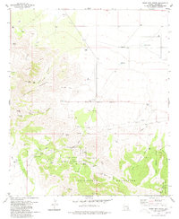
1979 Map of Bowie Mtn North
USGS Topo · Published 1981About this map
Fort Bowie Ruins, situated within the Fort Bowie National Historic Site, serves as the primary historical anchor for this late 1970s survey. The landscape is defined by the convergence of the Dos Cabezas Mountains and the Chiricahua Mountains at the strategically vital Apache Pass. Water sources like Apache Spring, Goodwin Spring, and Indian Spring were critical for sustaining early travel and settlement in this arid environment. The map details a ranching and mining economy, evidenced by the Ninemile Ranch, Hyl Ranch, and the Silverstrike Mine. A network of Jeep Trails and unnamed pipelines weave through Emigrant Canyon and Siphon Canyon, illustrating how modern infrastructure was integrated into the difficult terrain of the Old Military Reservation Boundary.
Find a feature on this map
50 named features on this map. Tap any name to fly to it.
Don’t see what you’re looking for? This feature index may not catch every label — zoom into the map to look around manually.
Map Details
Editions of this 1979 Bowie Mtn North Map
2 editions found
Other maps of this area

1917 · San Simon
USGS Topo · 1:125,000

1922 · Willcox
USGS Topo · 1:125,000

1926 · Cochise Head
USGS Topo · 1:62,500

1928 · Bowie
USGS Topo · 1:62,500

1943 · Dos Cabezas
USGS Topo · 1:62,500

1944 · Fisher Hills
USGS Topo · 1:62,500

1949 · Bowie
USGS Topo · 1:62,500

1950 · Bowie
USGS Topo · 1:62,500

1950 · Cochise Head
USGS Topo · 1:62,500

1954 · Silver City
USGS Topo · 1:250,000