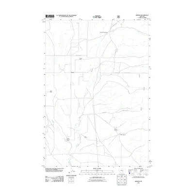
2011 Map of Bowler
USGS Topo · Published 2011About this map
Bowler and its surrounding high plains are defined by the winding course of Sage Creek as it flows through this corner of Carbon County. The landscape is marked by the expansive Bowler Flats and the distinct elevation of Black Butte to the west. This 2011 survey documents a rural environment where infrastructure and land use are clearly traced through a long-standing Railroad Grade and a network of mountain roads such as Pryor Mountain Rd and Pryor Creek Rd. Water management is evident in the presence of the Marlow Number 2 Dam, while the community's local history is anchored by the Bowler Cemetery. Further east, the terrain becomes more complex, transitioning into deep-cut features like Section House Draw, Timber Canyon, and Water Canyon, reflecting the drainage patterns and geographical character of the Pryor Mountain foothills.
Find a feature on this map
16 named features on this map. Tap any name to fly to it.
Don’t see what you’re looking for? This feature index may not catch every label — zoom into the map to look around manually.
Map Details
Editions of this 2011 Bowler Map
This is the sole edition of this map. No revisions or reprints were ever made.
Other maps of this area

1954 · Billings
USGS Topo · 1:250,000

1957 · Billings
USGS Topo · 1:250,000

1958 · Billings
USGS Topo · 1:250,000

1967 · Castle Rocks
USGS Topo · 1:24,000

1967 · Section House Draw
USGS Topo · 1:24,000

1967 · Bluewater
USGS Topo · 1:24,000

1969 · Warren
USGS Topo · 1:24,000

1969 · Bowler
USGS Topo · 1:24,000
1969 · Bear Canyon
USGS Topo · 1:24,000
1969 · Hunters Creek
USGS Topo · 1:24,000