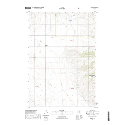
2020 Map of Bowler
USGS Topo · Published 2020About this map
Bowler sits as a quiet focal point in this high-plains landscape where the Carbon County and Big Horn County line meets. The terrain is defined by dramatic erosion, featuring Black Butte and deep cuts like Section House Draw and Inferno Canyon. To the east, the boundary of the Custer National Forest rises into the foothills, crossed by the Miller Trail and Stockman Trail. Evidence of past transportation infrastructure is visible in the naming of Railroad Grade Rd and Rail Bed Rd, which trace the path of former rail lines through the Bowler Flats. For genealogists and local historians, the Bowler Cem remains a significant marker of the families who settled this territory along Sage Cr.
Find a feature on this map
24 named features on this map. Tap any name to fly to it.
Don’t see what you’re looking for? This feature index may not catch every label — zoom into the map to look around manually.
Map Details
Editions of this 2020 Bowler Map
This is the sole edition of this map. No revisions or reprints were ever made.
Other maps of this area

1954 · Billings
USGS Topo · 1:250,000

1957 · Billings
USGS Topo · 1:250,000

1958 · Billings
USGS Topo · 1:250,000

1967 · Castle Rocks
USGS Topo · 1:24,000

1967 · Section House Draw
USGS Topo · 1:24,000

1967 · Bluewater
USGS Topo · 1:24,000

1969 · Warren
USGS Topo · 1:24,000

1969 · Bowler
USGS Topo · 1:24,000
1969 · Bear Canyon
USGS Topo · 1:24,000
1969 · Hunters Creek
USGS Topo · 1:24,000