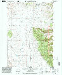
1996 Map of Bowler
USGS Topo · Published 1999About this map
The high plains and rugged breaks of the Montana-Wyoming border define this landscape near Bowler, where the Crow Indian Reservation meets the Custer National Forest. This 1996 revision highlights a region shaped by natural drainages like Sage Creek and Summit Creek, as well as human infrastructure like the multiple Pipelines traversing the Bowler Flats. The map reveals a land of transition, where the relatively level flats give way to the steep topography of Pryor Mountain and complex canyon systems including Timber Canyon and Inferno Canyon.
Find a feature on this map
25 named features on this map. Tap any name to fly to it.
Don’t see what you’re looking for? This feature index may not catch every label — zoom into the map to look around manually.
Map Details
Editions of this 1996 Bowler Map
This is the sole edition of this map. No revisions or reprints were ever made.
Other maps of this area

1954 · Billings
USGS Topo · 1:250,000

1957 · Billings
USGS Topo · 1:250,000

1958 · Billings
USGS Topo · 1:250,000

1967 · Castle Rocks
USGS Topo · 1:24,000

1967 · Section House Draw
USGS Topo · 1:24,000

1967 · Bluewater
USGS Topo · 1:24,000

1969 · Warren
USGS Topo · 1:24,000

1969 · Bowler
USGS Topo · 1:24,000
1969 · Bear Canyon
USGS Topo · 1:24,000
1969 · Hunters Creek
USGS Topo · 1:24,000