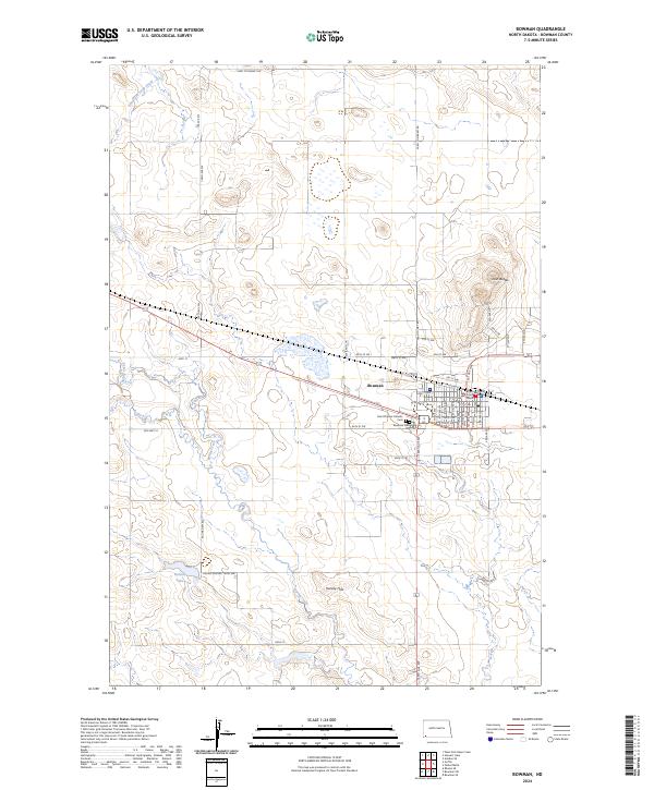
2024 Map of Bowman
USGS Topo · Published 2024About this map
Bowman serves as the focal point of this southwestern North Dakota landscape, situated at the junction of Hwy 12 and 146th Ave SW. The town's civic heart is anchored by the Bowman County Court House, with a residential grid extending southward toward the Bowman Cem and Saint Charles Catholic church. The surrounding terrain is defined by the high ground of Twin Buttes to the northeast and the Harvey Hills to the south, while the hydrological network includes the East Fork Deep Creek and the meandering Spring Creek. A notable agricultural and transportation infrastructure is evident through the prevalence of section-line roads like Farm to Market Rd and the presence of Kalina Lake, which is reached via Kalina Dam Rd. The spatial relationship between the modern highway and Old Hwy 12 illustrates the evolution of transit through this prairie region.
Find a feature on this map
50 named features on this map. Tap any name to fly to it.
Don’t see what you’re looking for? This feature index may not catch every label — zoom into the map to look around manually.
Map Details
Editions of this 2024 Bowman Map
This is the sole edition of this map. No revisions or reprints were ever made.
Other maps of this area

1953 · Dickinson
USGS Topo · 1:250,000

1957 · Dickinson
USGS Topo · 1:250,000

1968 · Bowman SW
USGS Topo · 1:24,000

1968 · Bowman
USGS Topo · 1:24,000

1973 · Talbot Butte
USGS Topo · 1:24,000

1973 · Amidon SE
USGS Topo · 1:24,000
1973 · Rhame SE
USGS Topo · 1:24,000
1973 · Bowman SE
USGS Topo · 1:24,000

1973 · Stewart Lake
USGS Topo · 1:24,000

1973 · Griffin
USGS Topo · 1:24,000