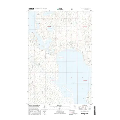
2016 Map of Bowstring Lake
USGS Topo · Published 2016About this map
The settlement of Inger serves as a focal point in this portion of the Chippewa National Forest, situated near the headwaters of the Bowstring River. This landscape is defined by its intricate network of interconnected waterways and lakes, including Rush Island Lake, Sand Lake, and the expansive Bowstring Lake to the south. Historically significant trails like the Cut Foot Sioux N R T traverse the wooded terrain, reflecting the long-standing importance of this region for navigation and transit through the northern forests. Local history is anchored by sites such as the Inger Cem and Donnelly Cem, providing tangible links for genealogists and researchers. To the southeast, the terrain begins its ascent toward the Mesabi Range, while the presence of the Bowstring Airport and various forest roads such as Silver Spider Forge Rd highlight the area's mid-20th-century development for forestry and limited aviation access.
Find a feature on this map
33 named features on this map. Tap any name to fly to it.
Don’t see what you’re looking for? This feature index may not catch every label — zoom into the map to look around manually.
Map Details
Editions of this 2016 Bowstring Lake Map
This is the sole edition of this map. No revisions or reprints were ever made.
Other maps of this area
1919 · Max
USGS Topo · 1:62,500

1954 · Bemidji
USGS Topo · 1:250,000

1954 · Hibbing
USGS Topo · 1:250,000

1957 · Bemidji
USGS Topo · 1:250,000

1957 · Hibbing
USGS Topo · 1:250,000

1958 · Bemidji
USGS Topo · 1:250,000

1958 · Hibbing
USGS Topo · 1:250,000

1964 · Hibbing
USGS Topo · 1:250,000
1970 · Bowstring Lake
USGS Topo · 1:24,000
1970 · Deer River NE
USGS Topo · 1:24,000