
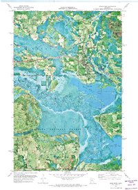
1970 Map of Deer River NE
USGS Topo · Published 1973About this map
Chippewa National Forest and Bowstring State Forest dominate this 1970 orthophotomap, showing the dense timberlands and wetland systems of northern Minnesota as they appeared through aerial photography. The map provides a precise look at the O-Ne-A-Ge-N Indian Reservation Boundary as it cuts through a landscape defined by significant water bodies like Rice Lake and the meandering Bowstring R. Several industrial Gravel Pits are visible near the confluence of the Deer River and Evans River, marking the intersection of resource extraction and protected wilderness. A dedicated Winter Trail in the northwestern quadrant highlights the importance of seasonal access in this lake-heavy terrain, where Grouse Creek and a prominent Ridge shape the local topography outside the primary river valleys.
Find a feature on this map
17 named features on this map. Tap any name to fly to it.
Don’t see what you’re looking for? This feature index may not catch every label — zoom into the map to look around manually.
Map Details
Editions of this 1970 Deer River NE Map
This is the sole edition of this map. No revisions or reprints were ever made.
Other maps of this area

1919 · Marcell
USGS Topo · 1:62,500

1953 · Cohasset West
USGS Topo · 1:24,000

1954 · Hibbing
USGS Topo · 1:250,000

1957 · Hibbing
USGS Topo · 1:250,000

1958 · Hibbing
USGS Topo · 1:250,000

1964 · Hibbing
USGS Topo · 1:250,000

1970 · Bowstring Lake
USGS Topo · 1:24,000

1970 · Jessie Lake
USGS Topo · 1:24,000
1970 · Deer River
USGS Topo · 1:24,000

1970 · Ball Club
USGS Topo · 1:24,000