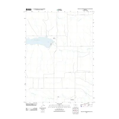
2011 Map of Box Butte Reservoir East
USGS Topo · Published 2011About this map
Box Butte Reservoir dominates the northwestern portion of this landscape, its waters held by the Box Butte Dam at the western edge of the high plains. The Niobrara River flows eastward from the reservoir, carving a distinct path through the terrain as it passes south of Dunlap Rd. The surrounding area is defined by a grid of rural routes like Table Center Rd and Banner Rd, which provide access to the agricultural lands between significant watercourses. To the north, Cottonwood Creek meanders through the plains, while the southern reaches are marked by the branching drainages of Sand Canyon and South Branch Sand Canyon. The presence of Cottonwood School Rd suggests the historical footprint of rural education in this corner of Box Butte County.
Find a feature on this map
18 named features on this map. Tap any name to fly to it.
Don’t see what you’re looking for? This feature index may not catch every label — zoom into the map to look around manually.
Map Details
Editions of this 2011 Box Butte Reservoir East Map
This is the sole edition of this map. No revisions or reprints were ever made.
Other maps of this area
1946 · Nonpareil
USGS Topo · 1:24,000
1946 · Box Butte Reservoir West
USGS Topo · 1:24,000
1947 · Box Butte NW
USGS Topo · 1:24,000
1948 · Box Butte Reservoir West
USGS Topo · 1:24,000
1948 · Hemingford
USGS Topo · 1:24,000
1948 · Nonpareil
USGS Topo · 1:24,000
1948 · Box Butte Reservoir East
USGS Topo · 1:24,000
1949 · Box Butte SW
USGS Topo · 1:24,000
1949 · Box Butte NW
USGS Topo · 1:24,000
1955 · Alliance
USGS Topo · 1:250,000