
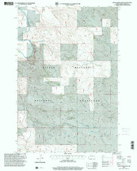
1980 Map of Boyce Creek West
USGS Topo · Published 1980About this map
The Little Missouri River meanders through the northwest corner of this Slope County landscape, defining a terrain shaped by deep drainage networks. In the late 1970s, when these aerial photographs were captured, the area remained a strictly rural expanse of rangeland and resource extraction. The map reveals a high concentration of Flowing Wells and individual wells scattered across the township lines of T 135 N and T 134 N, indicating the vital importance of groundwater in this arid environment. Significant landforms like Sunshine Mound overlook the winding courses of Boyce Creek, Cash Creek, and Indian Creek. Notable human activity is limited to a few structures and specialized industrial sites, such as a Gravel Pit and Sand Pit located in the southeastern quadrant, reflecting the local geology and the practical needs of the region's infrastructure during this era.
Find a feature on this map
13 named features on this map. Tap any name to fly to it.
Don’t see what you’re looking for? This feature index may not catch every label — zoom into the map to look around manually.
Map Details
Editions of this 1980 Boyce Creek West Map
This is the sole edition of this map. No revisions or reprints were ever made.
Other maps of this area

1953 · Dickinson
USGS Topo · 1:250,000

1957 · Dickinson
USGS Topo · 1:250,000

1979 · Three V Crossing
USGS Topo · 1:24,000

1979 · Ives
USGS Topo · 1:24,000

1980 · Spring Creek
USGS Topo · 1:24,000

1980 · Pretty Butte
USGS Topo · 1:24,000

1980 · Marmarth
USGS Topo · 1:24,000

1980 · Belfield
USGS Topo · 1:100,000

1981 · Bowman
USGS Topo · 1:100,000
1997 · Boyce Creek West
USGS Topo · 1:24,000