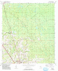
1954 Map of Boyd
USGS Topo · Published 1993About this map
Perry sits at the southern edge of this Taylor County landscape, serving as a hub for the surrounding pine flatwoods and wetland margins of San Pedro Bay. The map documents the mid-century transition of the area, featuring a Drive-in Theater and Radio Sta near the town center, while smaller settlements like Boyd and Lake Bird anchor the rural northern tracts. These smaller communities are defined by their local institutions, including Shiloh Ch and its adjacent Shiloh Cem, which provide valuable location data for genealogists tracing North Florida families.
Find a feature on this map
17 named features on this map. Tap any name to fly to it.
Don’t see what you’re looking for? This feature index may not catch every label — zoom into the map to look around manually.
Map Details
Editions of this 1954 Boyd Map
2 editions found
Other maps of this area

1952 · Secotan
USGS Topo · 1:24,000

1954 · Fenholloway
USGS Topo · 1:24,000

1954 · Boyd
USGS Topo · 1:24,000

1954 · Hampton Springs
USGS Topo · 1:24,000

1954 · Secotan
USGS Topo · 1:24,000

1954 · Day NW
USGS Topo · 1:24,000

1954 · Valdosta
USGS Topo · 1:250,000

1955 · Perry
USGS Topo · 1:24,000

1955 · Shady Grove
USGS Topo · 1:24,000

1955 · Greenville SE
USGS Topo · 1:24,000