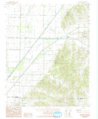
1984 Map of Boydsville
USGS Topo · Published 1993About this map
Crowleys Ridge dominates the eastern half of this 1980s landscape, providing a sharp topographical contrast to the low-lying agricultural plains of the Mississippi Alluvial Plain. This rise in elevation defines the local settlement patterns, with the historic community of Boydsville and Lower Boydsville positioned along the western edge of the ridge. The map illustrates a complex water management system essential to the region's farming economy, where natural waterways like the Cache River and Big Creek are supplemented by engineered features such as Big North Ditch. Small, dispersed settlements like Tipperary and the high-point community of Knob dot the landscape, reflecting a rural lifestyle deeply tied to the land. Along the southern edge, the Clay Co Greene Co boundary line marks the intersection of these two northeast Arkansas counties, while local drainages like Johnson Creek and Dort Creek wind through the timbered slopes of the ridge.
Find a feature on this map
11 named features on this map. Tap any name to fly to it.
Don’t see what you’re looking for? This feature index may not catch every label — zoom into the map to look around manually.
Map Details
Editions of this 1984 Boydsville Map
2 editions found
Other maps of this area

1935 · Rector
USGS Topo · 1:62,500

1935 · Knobel
USGS Topo · 1:62,500

1940 · Gainesville
USGS Topo · 1:62,500

1940 · Marmaduke
USGS Topo · 1:62,500

1941 · Knobel
USGS Topo · 1:62,500

1957 · Poplar Bluff
USGS Topo · 1:250,000

1958 · Marmaduke
USGS Topo · 1:62,500

1958 · Gainesville
USGS Topo · 1:62,500

1958 · Rector
USGS Topo · 1:62,500

1959 · Poplar Bluff
USGS Topo · 1:250,000