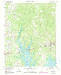
1968 Map of Boydton
USGS Topo · Published 1990About this map
The town of Boydton serves as a central hub on this Mecklenburg County landscape, just as the John H Kerr Reservoir reshaped the southern terrain. This 1968 survey, with later revisions in purple, documents the area's transition into a recreation-friendly region following the creation of the reservoir. Numerous inlets and branches, such as Butcher Creek and Eastland Creek, reach deep into the wooded uplands, creating a complex shoreline that surrounds the Rudd Creek Public Use Area.
Find a feature on this map
34 named features on this map. Tap any name to fly to it.
Don’t see what you’re looking for? This feature index may not catch every label — zoom into the map to look around manually.
Map Details
Editions of this 1968 Boydton Map
Other maps of this area

1941 · Clarksville
USGS Topo · 1:48,000

1943 · Clarksville
USGS Topo · 1:62,500

1953 · Greensboro
USGS Topo · 1:250,000

1954 · Greensboro
USGS Topo · 1:250,000

1954 · Clover
USGS Topo · 1:62,500

1955 · Chase City
USGS Topo · 1:62,500

1955 · Boydton
USGS Topo · 1:62,500

1957 · Clarksville
USGS Topo · 1:62,500

1962 · Greensboro
USGS Topo · 1:250,000

1966 · Greensboro
USGS Topo · 1:250,000