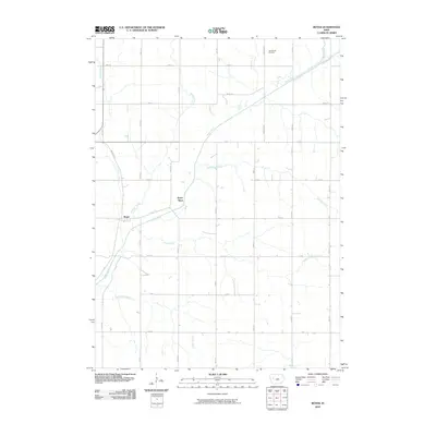
2010 Map of Boyer
USGS Topo · Published 2010About this map
Boyer River and its numerous tributaries dominate this western Iowa landscape, where the small settlement of Boyer sits at a critical junction of local waterways and roads. The map reveals an intricate network of rural section lines, including Boyer Blvd, A Ave, and Gard Ave, which partition the agricultural terrain. Water drainage patterns are clearly defined by Porter Creek to the west and Wheeler Creek and Beamon Creek to the east, illustrating the rolling topography typical of the region. Genealogists and local historians will find the location of the Tom Marks Cemetery near the northern boundary especially valuable, as it stands as a permanent marker of the area's early residents. The mapping reflects a stabilized rural community defined by its watercourses, such as Trinkle Creek and Tucker Creek, which cut through the grid of county roads.
Find a feature on this map
32 named features on this map. Tap any name to fly to it.
Don’t see what you’re looking for? This feature index may not catch every label — zoom into the map to look around manually.
Map Details
Editions of this 2010 Boyer Map
This is the sole edition of this map. No revisions or reprints were ever made.
Other maps of this area

1954 · Fort Dodge
USGS Topo · 1:250,000

1957 · Fort Dodge
USGS Topo · 1:250,000

1958 · Fort Dodge
USGS Topo · 1:250,000

1971 · Denison
USGS Topo · 1:24,000

1971 · Kiron
USGS Topo · 1:24,000

1980 · Odebolt East
USGS Topo · 1:24,000

1980 · Lake View
USGS Topo · 1:24,000

1980 · Boyer
USGS Topo · 1:24,000
1980 · Vail NE
USGS Topo · 1:24,000
1980 · Arcadia
USGS Topo · 1:24,000