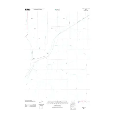
2013 Map of Boyer
USGS Topo · Published 2013About this map
The small settlement of Boyer sits at the heart of this Crawford County landscape, where the Boyer River winds through a strictly surveyed grid of agricultural lands. In the early 21st century, this area remains defined by its watercourses and a dense network of local roads such as Wall Lake Rd and Boyer Blvd. The drainage patterns are intricate, with several named tributaries including Porter Cr, Tucker Cr, and Wheeler Cr carving through the prairie. The map documents the persistent rural character of the region, where named avenues and streets like Jackson Ave and 380th St provide the primary structure for farmstead access. This survey is a precise record of the land as it appeared before further modern consolidation, useful for tracing family property lines and local creek crossings like Trinkle Cr and Beamon Cr.
Find a feature on this map
32 named features on this map. Tap any name to fly to it.
Don’t see what you’re looking for? This feature index may not catch every label — zoom into the map to look around manually.
Map Details
Editions of this 2013 Boyer Map
This is the sole edition of this map. No revisions or reprints were ever made.
Other maps of this area

1954 · Fort Dodge
USGS Topo · 1:250,000

1957 · Fort Dodge
USGS Topo · 1:250,000

1958 · Fort Dodge
USGS Topo · 1:250,000

1971 · Denison
USGS Topo · 1:24,000

1971 · Kiron
USGS Topo · 1:24,000

1980 · Odebolt East
USGS Topo · 1:24,000

1980 · Lake View
USGS Topo · 1:24,000

1980 · Boyer
USGS Topo · 1:24,000
1980 · Vail NE
USGS Topo · 1:24,000
1980 · Arcadia
USGS Topo · 1:24,000