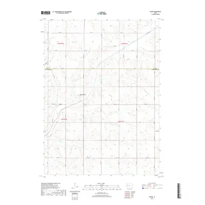
2018 Map of Boyer
USGS Topo · Published 2018About this map
Boyer River flows diagonally through the center of this western Iowa landscape, serving as the primary drainage for a network of local tributaries including Wheeler Cr, Trinkle Cr, and Beamon Cr. The small settlement of Boyer sits at the intersection of Co Hwy E16 and Boyer Blvd, representing the primary population center in this agricultural region. The map illustrates a highly organized grid of rural roads, such as Wall Lake Rd and Co Hwy M40, which facilitate movement between the sprawling farmsteads typical of the era. The boundary between Sac Co and Crawford Co runs through the northern portion of the quadrangle, dividing the townships of T86N and T85N. This survey provides a clear view of the drainage patterns of the Missouri River basin, characterized by the winding paths of Tucker Cr and Lime Cr through the loess hills.
Find a feature on this map
41 named features on this map. Tap any name to fly to it.
Don’t see what you’re looking for? This feature index may not catch every label — zoom into the map to look around manually.
Map Details
Editions of this 2018 Boyer Map
This is the sole edition of this map. No revisions or reprints were ever made.
Other maps of this area

1954 · Fort Dodge
USGS Topo · 1:250,000

1957 · Fort Dodge
USGS Topo · 1:250,000

1958 · Fort Dodge
USGS Topo · 1:250,000

1971 · Denison
USGS Topo · 1:24,000

1971 · Kiron
USGS Topo · 1:24,000

1980 · Odebolt East
USGS Topo · 1:24,000

1980 · Lake View
USGS Topo · 1:24,000

1980 · Boyer
USGS Topo · 1:24,000
1980 · Vail NE
USGS Topo · 1:24,000
1980 · Arcadia
USGS Topo · 1:24,000