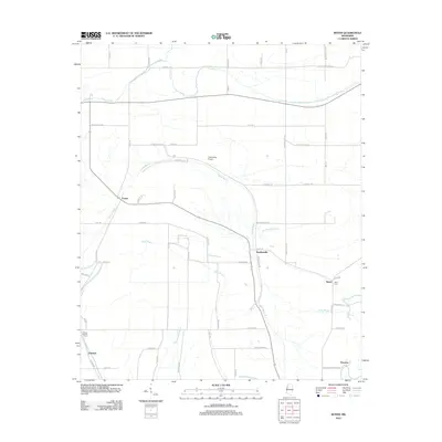
2012 Map of Boyer
USGS Topo · Published 2012About this map
Porter Bayou and Bear Bayou snake across this rural Sunflower County landscape, defining the agricultural drainage patterns of the Mississippi Delta. The small settlements of Boyer and Stephenville anchor a network of local roads such as Lyon Bridge Rd and Bates Triplett Rd, illustrating the dispersed residential character of the region in the early 21st century. For genealogists, the map identifies key burial sites including Mount Calvary Cem near Fairview and the Boyer Cem to the east. Transportation and infrastructure are represented by the Cottonwing Airport and several smaller waterways like Moorhead Bayou and Beaver Dam Bayou. This topographic record provides a clear view of the area's rural development and water-dependent landscape before more recent shifts in Delta land use.
Find a feature on this map
62 named features on this map. Tap any name to fly to it.
Don’t see what you’re looking for? This feature index may not catch every label — zoom into the map to look around manually.
Map Details
Editions of this 2012 Boyer Map
This is the sole edition of this map. No revisions or reprints were ever made.
Other maps of this area

1934 · Cleveland
USGS Topo · 1:62,500

1939 · Tralake
USGS Topo · 1:62,500

1939 · Choctaw
USGS Topo · 1:62,500

1940 · Baird
USGS Topo · 1:62,500

1940 · Cleveland
USGS Topo · 1:62,500

1953 · Greenwood
USGS Topo · 1:250,000

1956 · Greenwood
USGS Topo · 1:250,000

1965 · Indianola
USGS Topo · 1:24,000

1966 · Cleveland
USGS Topo · 1:24,000
1966 · Sunflower
USGS Topo · 1:24,000