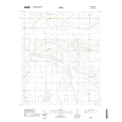
2020 Map of Boyer
USGS Topo · Published 2020About this map
Boyer, Frazier, and Fairview anchor this agricultural landscape in the Mississippi Delta, where the drainage patterns of several major bayous define the land use. The Big Sunflower River brushes the southeastern corner, while the complex meandering paths of Porter Bayou and Moorhead Bayou wind through the township grids. This network of waterways is complemented by a dense system of local roads often named for resident families, such as Hughes Walker Rd and Bates Triplett Rd. Local heritage is preserved at the Boyer Cem and Mount Calvary Cem, providing critical landmarks for genealogists. The map illustrates the persistent intersection of natural watercourses and the rigid section lines of the Public Land Survey System, a hallmark of the Sunflower County and Bolivar County border region.
Find a feature on this map
61 named features on this map. Tap any name to fly to it.
Don’t see what you’re looking for? This feature index may not catch every label — zoom into the map to look around manually.
Map Details
Editions of this 2020 Boyer Map
This is the sole edition of this map. No revisions or reprints were ever made.
Other maps of this area

1934 · Cleveland
USGS Topo · 1:62,500

1939 · Tralake
USGS Topo · 1:62,500

1939 · Choctaw
USGS Topo · 1:62,500

1940 · Baird
USGS Topo · 1:62,500

1940 · Cleveland
USGS Topo · 1:62,500

1953 · Greenwood
USGS Topo · 1:250,000

1956 · Greenwood
USGS Topo · 1:250,000

1965 · Indianola
USGS Topo · 1:24,000

1966 · Cleveland
USGS Topo · 1:24,000
1966 · Sunflower
USGS Topo · 1:24,000