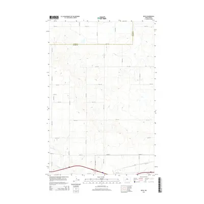
2014 Map of Boyle
USGS Topo · Published 2014About this map
Boyle and the surrounding rural plains of Stark County are documented in this 2014 survey, highlighting a landscape defined by its rigid section-line grid and riparian drainage. The Green River meanders across the southern portion of the map, providing a natural contrast to the geometric precision of the local road network. Transport routes are dominated by east-west thoroughfares including Highway 10 and 37th St SW, which parallel the river's course. North of the river, the terrain rises into upland prairies divided by a systematic network of avenues such as 103rd Ave SW and 100th Ave SW. This survey captures the county boundary where Dunn Co meets Stark Co along 30th St SW, reflecting the persistent administrative and agricultural organization of the North Dakota landscape in the early 21st century.
Find a feature on this map
24 named features on this map. Tap any name to fly to it.
Don’t see what you’re looking for? This feature index may not catch every label — zoom into the map to look around manually.
Map Details
Editions of this 2014 Boyle Map
This is the sole edition of this map. No revisions or reprints were ever made.
Other maps of this area
1953 · Dickinson
USGS Topo · 1:250,000
1953 · Watford City
USGS Topo · 1:250,000
1957 · Dickinson
USGS Topo · 1:250,000
1957 · Watford City
USGS Topo · 1:250,000
1959 · Lehigh
USGS Topo · 1:24,000
1962 · Davis Buttes
USGS Topo · 1:24,000
1967 · Watford City
USGS Topo · 1:250,000
1973 · Bratburg Butte
USGS Topo · 1:24,000
1973 · Boyle
USGS Topo · 1:24,000
1973 · Taylor
USGS Topo · 1:24,000