
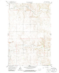
1959 Map of Lehigh
USGS Topo · Published 1960About this map
Heart River meanders through the northern portion of this Stark County landscape, where the town of Lehigh sits alongside the Northern Pacific railroad tracks. This mid-century survey captures a transitional industrial environment, marked by an active Strip Mine and scattered Gravel Pits that suggest the region's reliance on mineral extraction. The terrain is defined by the prominent Dobson Buttes rising to the west, while the agricultural character of the era is evident in the placement of rural schools like Shipley Sch No 3 and Shipley Sch No 4.
Find a feature on this map
13 named features on this map. Tap any name to fly to it.
Don’t see what you’re looking for? This feature index may not catch every label — zoom into the map to look around manually.
Map Details
Editions of this 1959 Lehigh Map
2 editions found
Other maps of this area

1953 · Dickinson
USGS Topo · 1:250,000

1957 · Dickinson
USGS Topo · 1:250,000

1959 · Dickinson North
USGS Topo · 1:24,000

1959 · Dickinson South
USGS Topo · 1:24,000

1962 · Davis Buttes
USGS Topo · 1:24,000

1973 · Boyle
USGS Topo · 1:24,000

1973 · Lefor NW
USGS Topo · 1:24,000

1973 · Lefor
USGS Topo · 1:24,000

1973 · Gladstone
USGS Topo · 1:24,000

1973 · Schefield
USGS Topo · 1:24,000