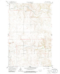
1959 Map of Lehigh
USGS Topo · Published 1986About this map
The Heart River winds through this Stark County landscape, anchoring a rural territory defined by the extraction of lignite and early transportation routes. Near the settlement of Lehigh, the presence of a Strip Mine and a Scoria Pit indicates the area's industrial importance during the mid-20th century. The Northern Pacific railroad parallels the river, facilitating the movement of coal and agricultural goods from the high plains.
Find a feature on this map
16 named features on this map. Tap any name to fly to it.
Don’t see what you’re looking for? This feature index may not catch every label — zoom into the map to look around manually.
Map Details
Editions of this 1959 Lehigh Map
2 editions found
Other maps of this area

1953 · Dickinson
USGS Topo · 1:250,000

1957 · Dickinson
USGS Topo · 1:250,000

1959 · Dickinson North
USGS Topo · 1:24,000

1959 · Dickinson South
USGS Topo · 1:24,000

1959 · Lehigh
USGS Topo · 1:24,000

1962 · Davis Buttes
USGS Topo · 1:24,000

1973 · Boyle
USGS Topo · 1:24,000

1973 · Lefor NW
USGS Topo · 1:24,000

1973 · Lefor
USGS Topo · 1:24,000

1973 · Gladstone
USGS Topo · 1:24,000