
1962 Map of Davis Buttes
USGS Topo · Published 1964About this map
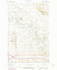
Dickinson Air Force Station occupies a prominent position in this western North Dakota landscape, situated atop the rising elevations of the Davis Buttes. The survey captures a period of transition in the early 1960s, evidenced by a major road marked as under construction spanning the southern portion of the quadrangle. This infrastructure project parallels the winding course of the Heart River, which cuts through the bottom of the map near a marked Ford. To the north, the Green River and Russian Spring Creek define the drainage patterns of the area, winding past several gravel pits that suggest the local industry of the era. The rural social fabric is anchored by the Versippi Sch, while natural landmarks like Simon Butte provide distinct navigational points for those studying the historical topography of Stark and Dunn counties.
Find a feature on this map
15 named features on this map. Tap any name to fly to it.
Don’t see what you’re looking for? This feature index may not catch every label — zoom into the map to look around manually.
Map Details
Editions of this 1962 Davis Buttes Map
2 editions found
Other maps of this area

1953 · Dickinson
USGS Topo · 1:250,000

1953 · Watford City
USGS Topo · 1:250,000

1957 · Dickinson
USGS Topo · 1:250,000

1957 · Watford City
USGS Topo · 1:250,000

1959 · Dickinson North
USGS Topo · 1:24,000

1959 · Dickinson South
USGS Topo · 1:24,000

1959 · Lehigh
USGS Topo · 1:24,000

1967 · Watford City
USGS Topo · 1:250,000

1973 · Boyle
USGS Topo · 1:24,000

1973 · Manning SE
USGS Topo · 1:24,000