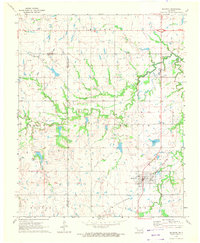
1971 Map of Boynton
USGS Topo · Published 1972About this map
The town of Boynton serves as the focal point of this eastern Oklahoma landscape, positioned at a junction where the St Louis - San Francisco railroad cuts across the prairie. By the early 1970s, the region's character was defined by a mix of agriculture and the legacy of the local Oil Field, with numerous Oil Wells scattered across the northern sections. The terrain is marked by distinct townships and local elevations such as Bald Hill and Sutton, while the drainage system is dominated by the meandering Cane Creek and Walnut Creek.
Find a feature on this map
22 named features on this map. Tap any name to fly to it.
Don’t see what you’re looking for? This feature index may not catch every label — zoom into the map to look around manually.
Map Details
Editions of this 1971 Boynton Map
2 editions found
Other maps of this area

1896 · Okmulgee
USGS Topo · 1:125,000

1900 · Okmulgee
USGS Topo · 1:125,000

1946 · Fort Smith
USGS Topo · 1:250,000

1965 · Fort Smith
USGS Topo · 1:250,000

1967 · Fort Smith
USGS Topo · 1:250,000
1970 · Wainwright
USGS Topo · 1:24,000
1970 · Council Hill
USGS Topo · 1:24,000
1970 · Morris
USGS Topo · 1:24,000
1971 · Beland
USGS Topo · 1:24,000
1971 · Okmulgee NE
USGS Topo · 1:24,000