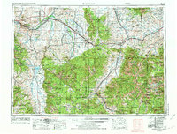
1958 Map of Bozeman
USGS Topo · Published 1974About this map
Bozeman and Livingston serve as the primary hubs in this regional survey, which captures the high-altitude landscape of southwestern Montana during the transition to the Burlington Northern era. The map details the complex drainage systems of the Gallatin River, Madison River, and Yellowstone River, illustrating how these waterways dictated the placement of early settlements and rail lines. Notable is the industrial presence at Trident and the small agricultural pockets around Manhattan and Church Hill.
Find a feature on this map
190 named features on this map. Tap any name to fly to it.
Don’t see what you’re looking for? This feature index may not catch every label — zoom into the map to look around manually.
Map Details
Editions of this 1958 Bozeman Map
3 editions found

Other maps of this area

1885 · Gallatin
USGS Topo · 1:125,000

1885 · Gallatin
USGS Topo · 1:125,000

1886 · Fort Logan
USGS Topo · 1:250,000

1886 · Canyon
USGS Topo · 1:125,000

1886 · Little Belt Mts.
USGS Topo · 1:250,000

1888 · Three Forks
USGS Topo · 1:250,000

1889 · Big Snowy Mountain
USGS Topo · 1:250,000

1889 · Helena
USGS Topo · 1:250,000

1891 · Livingston
USGS Topo · 1:250,000

1891 · Big Timber
USGS Topo · 1:125,000