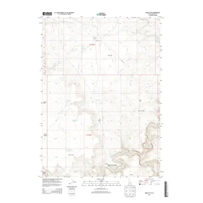
2013 Map of Brace Flat
USGS Topo · Published 2013About this map
Brace Ranch and Twin Springs Ranch represent the sparse ranching outposts established in this arid corner of Owyhee County during the early 21st century. The landscape is defined by its water management systems, featuring a series of catchments including Brace Reservoir, Porcupine Reservoir, and the Center Lambert Reservoir to support livestock in the high desert. To the south, the Owyhee River snakes through Owyhee Canyon, passing notable geographic landmarks such as Rickard Crossing and the prominent rise of The Dome. The historic Kimball Trl cuts across the northern flats, connecting the open stretches of Brace Flat with the surrounding high country. This survey illustrates the vital relationship between the seasonal flow of Beaver Cr or Porcupine Cr and the sustainability of remote Idaho homesteads.
Find a feature on this map
34 named features on this map. Tap any name to fly to it.
Don’t see what you’re looking for? This feature index may not catch every label — zoom into the map to look around manually.
Map Details
Editions of this 2013 Brace Flat Map
This is the sole edition of this map. No revisions or reprints were ever made.
Other maps of this area

1955 · Jordan Valley
USGS Topo · 1:250,000

1957 · Jordan Valley
USGS Topo · 1:250,000

1958 · Jordan Valley
USGS Topo · 1:250,000

1973 · Red Basin
USGS Topo · 1:24,000
1973 · Piute Basin West
USGS Topo · 1:24,000

1973 · Smith Creek
USGS Topo · 1:24,000

1973 · Castro Table
USGS Topo · 1:24,000

1973 · Grassy Ridge
USGS Topo · 1:24,000
1973 · Dickshooter Reservoir
USGS Topo · 1:24,000

1973 · Brace Flat
USGS Topo · 1:24,000