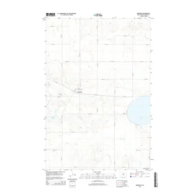
2014 Map of Braddock
USGS Topo · Published 2014About this map
Braddock serves as the central hub of this northern plains landscape, situated near the headwaters of Goose Creek. The area is characterized by the glacial topography of the Altamont Moraine, which shapes the drainage patterns of Long Lake Cr and creates natural basins for bodies of water like Goose Lake. For those tracing local heritage, the map identifies three distinct burial sites: Saint Katherines Cem north of town, Braddock Cem to the west, and the more isolated Maria Cem situated east of the main settlement. The presence of Braddock Dam indicates local water management efforts in this prairie environment, while the grid of section roads like 15th Ave SE and 59th St SE reflects the systematic agricultural division of the land.
Find a feature on this map
27 named features on this map. Tap any name to fly to it.
Don’t see what you’re looking for? This feature index may not catch every label — zoom into the map to look around manually.
Map Details
Editions of this 2014 Braddock Map
This is the sole edition of this map. No revisions or reprints were ever made.
Other maps of this area

1953 · Jamestown
USGS Topo · 1:250,000

1954 · Bismarck
USGS Topo · 1:250,000

1956 · Jamestown
USGS Topo · 1:250,000

1958 · Bismarck
USGS Topo · 1:250,000

1975 · Dana
USGS Topo · 1:24,000

1975 · Appert Lake
USGS Topo · 1:24,000

1975 · Linton NE
USGS Topo · 1:24,000
1975 · Braddock NW
USGS Topo · 1:24,000

1975 · Braddock
USGS Topo · 1:24,000
1975 · Braddock NE
USGS Topo · 1:24,000