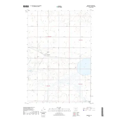
2018 Map of Braddock
USGS Topo · Published 2018About this map
Braddock anchors this corner of Emmons County, situated where Goose Creek winds through the glacial topography. The landscape is defined by the Altamont Moraine, a glacial feature that influences the drainage of Goose Lake and the various marshy basins found throughout the township. The town's grid is small and orderly, clustered near Railroad Ave E and Mitchell St, serving as a central point for the surrounding prairie homesteads.
Find a feature on this map
33 named features on this map. Tap any name to fly to it.
Don’t see what you’re looking for? This feature index may not catch every label — zoom into the map to look around manually.
Map Details
Editions of this 2018 Braddock Map
This is the sole edition of this map. No revisions or reprints were ever made.
Other maps of this area

1953 · Jamestown
USGS Topo · 1:250,000

1954 · Bismarck
USGS Topo · 1:250,000

1956 · Jamestown
USGS Topo · 1:250,000

1958 · Bismarck
USGS Topo · 1:250,000

1975 · Dana
USGS Topo · 1:24,000

1975 · Appert Lake
USGS Topo · 1:24,000

1975 · Linton NE
USGS Topo · 1:24,000
1975 · Braddock NW
USGS Topo · 1:24,000

1975 · Braddock
USGS Topo · 1:24,000
1975 · Braddock NE
USGS Topo · 1:24,000