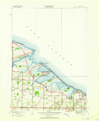
1952 Map of Braddock Heights
USGS Topo · Published 1962About this map
The marshy shoreline of Lake Ontario defines the landscape of the town of Greece in this mid-century revision. A series of large lagoons—including Braddock Bay, Cranberry Pond, Long Pond, and Buck Pond—are separated from the lake by narrow barrier beaches like Grand View Beach and Crescent Beach, which by the early 1950s had become developed with shoreline residential clusters. Inland, the transition from agricultural land to suburban settlement is evident near Greece Sta and North Greece, where the New York Central railroad tracks cut across the terrain. Small hamlets and named points such as Kuhn, Lowden Point, and Beatty Point reflect the local geography of the era, while infrastructure like School No 2 and a Sewage Disposal plant show the growing needs of the lakeside community.
Find a feature on this map
60 named features on this map. Tap any name to fly to it.
Don’t see what you’re looking for? This feature index may not catch every label — zoom into the map to look around manually.
Map Details
Editions of this 1952 Braddock Heights Map
4 editions found
Other maps of this area

1895 · Rochester
USGS Topo · 1:62,500

1895 · Ontario Beach
USGS Topo · 1:62,500

1898 · Rochester
USGS Topo · 1:62,500

1899 · Hamlin
USGS Topo · 1:62,500

1899 · Ontario Beach
USGS Topo · 1:62,500

1899 · Brockport
USGS Topo · 1:62,500

1912 · Rochester
USGS Topo · 1:62,500

1912 · Ontario Beach
USGS Topo · 1:62,500

1920 · Rochester
USGS Topo · 1:62,500

1931 · Rochester West
USGS Topo · 1:24,000