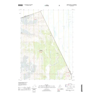
2018 Map of Bradfield Canal A-1 SE
USGS Topo · Published 2018About this map
Tongass National Forest dominates the landscape of this international borderlands survey, where the peaks of the Coast Mountains meet the high-altitude hydrology of the Alaska-Canada boundary. The map documents a complex network of glacial meltwater and alpine drainage, including Texas Creek and its many forks, which feed into the wider basin. The dramatic elevation change is punctuated by notable summits such as Mt Bayard and Ninemile Mtn, while the Salmon River valley serves as a primary corridor for transportation. Human presence in this high-relief terrain is concentrated along the State Highway 12 - Salmon River corridor and the winding Titan Trail. Further inland, isolated water bodies like Indian Lake, Noname Lake, and Tunnel Lake reflect the glacial character of the region near Mineral Hill and the international line.
Find a feature on this map
35 named features on this map. Tap any name to fly to it.
Don’t see what you’re looking for? This feature index may not catch every label — zoom into the map to look around manually.
Map Details
Editions of this 2018 Bradfield Canal A-1 SE Map
This is the sole edition of this map. No revisions or reprints were ever made.
Other maps of this area

1951 · Bradfield Canal
USGS Topo · 1:250,000

1952 · Ketchikan
USGS Topo · 1:250,000

1954 · Bradfield Canal
USGS Topo · 1:250,000

1955 · Bradfield Canal A-1
USGS Topo · 1:63,360

1955 · Ketchikan D-1
USGS Topo · 1:63,360

1955 · Ketchikan
USGS Topo · 1:250,000

1955 · Bradfield Canal
USGS Topo · 1:250,000
1996 · Bradfield Canal A-1
USGS Topo · 1:63,360
1997 · Bradfield Canal A-1
USGS Topo · 1:63,360
2000 · Bradfield Canal A-1
USGS Topo · 1:63,360