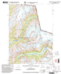
2000 Map of Bradfield Canal A-2
USGS Topo · Published 2003About this map
The Misty Fiords National Monument Wilderness dominates this landscape, showing a complex network of glacial activity and drainage within the Tongass National Forest. This survey, revised in 2000, illustrates the massive presence of the Gracey Creek Glacier and the Chickamin Glacier as they interact with the international border between Canada and the United States. The movement of ice from the Through Glacier feeds into the broad valley of the Chickamin River, while the Leduc River carves through the central portion of the monument. Notable peaks along the Alaskan-British Columbian boundary, such as Mt John Jay and Mt Upshur, define the high-altitude topography of the region. The map provides a critical look at the shifting glacial margins and high-country summits like Banded Mountain and Mt Wilson before the turn of the millennium.
Find a feature on this map
18 named features on this map. Tap any name to fly to it.
Don’t see what you’re looking for? This feature index may not catch every label — zoom into the map to look around manually.
Map Details
Editions of this 2000 Bradfield Canal A-2 Map
This is the sole edition of this map. No revisions or reprints were ever made.
Other maps of this area

1951 · Bradfield Canal
USGS Topo · 1:250,000

1952 · Ketchikan
USGS Topo · 1:250,000

1954 · Bradfield Canal
USGS Topo · 1:250,000

1955 · Bradfield canal B-2
USGS Topo · 1:63,360

1955 · Ketchikan D-2
USGS Topo · 1:63,360

1955 · Bradfield canal B-3
USGS Topo · 1:63,360

1955 · Bradfield canal A-2
USGS Topo · 1:63,360

1955 · Ketchikan D-3
USGS Topo · 1:63,360

1955 · Bradfield Canal A-1
USGS Topo · 1:63,360

1955 · Ketchikan D-1
USGS Topo · 1:63,360