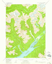
1955 Map of Bradfield canal A-4
USGS Topo · Published 1959About this map
Burroughs Bay serves as the focal point of this coastal wilderness, where glacial waters from several major river systems converge within the Tongass National Forest. The landscape is dominated by the massive Spur Mountain and a network of drainages including the Unuk River, Hulakon River, and Klahini River. While the terrain is primarily defined by its steep elevations and ice fields, evidence of human presence is found in small clearings along the riverbanks. The mapping identifies specific outposts such as Bishop Ranch and Matney Ranch near the mouth of the Unuk, alongside scattered cabin sites. These isolated settlements, along with markers like Jane No 2 and various VABM survey points, indicate the difficult work of mid-century navigation and land management in this coastal corridor.
Find a feature on this map
18 named features on this map. Tap any name to fly to it.
Don’t see what you’re looking for? This feature index may not catch every label — zoom into the map to look around manually.
Map Details
Editions of this 1955 Bradfield canal A-4 Map
2 editions found
Other maps of this area

1951 · Bradfield Canal
USGS Topo · 1:250,000

1952 · Ketchikan
USGS Topo · 1:250,000

1952 · Ketchikan D-5
USGS Topo · 1:63,360

1953 · Ketchikan D-5
USGS Topo · 1:63,360

1954 · Bradfield Canal
USGS Topo · 1:250,000

1955 · Bradfield canal B-3
USGS Topo · 1:63,360

1955 · Bradfield canal A-4
USGS Topo · 1:63,360

1955 · Bradfield canal B-5
USGS Topo · 1:63,360

1955 · Ketchikan D-4
USGS Topo · 1:63,360

1955 · Bradfield canal B-4
USGS Topo · 1:63,360