
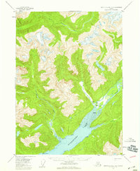
1955 Map of Bradfield canal A-4
USGS Topo · Published 1959About this map
Burroughs Bay dominates this mid-century survey of the southeastern Alaskan coast, where several major river systems converge in the Tongass National Forest. Settlement in this era was concentrated at the head of the bay, evidenced by the Bishop Ranch and Matney Ranch situated near the mouth of the Unuk River. The map shows a landscape defined by water and steep relief, with the Kulakon River and Klahini River feeding into the coastal waters near Willow Islands. Navigational markers and triangulation stations like VABM 13 Dick and VABM 11 Oak are scattered along the shoreline, reflecting the importance of maritime and aerial surveying in this roadless region during the 1950s. The presence of isolated cabins along Grant Creek and the bay suggests a seasonal or subsistence-based presence far from established towns.
Find a feature on this map
18 named features on this map. Tap any name to fly to it.
Don’t see what you’re looking for? This feature index may not catch every label — zoom into the map to look around manually.
Map Details
Editions of this 1955 Bradfield canal A-4 Map
2 editions found
Other maps of this area

1951 · Bradfield Canal
USGS Topo · 1:250,000

1952 · Ketchikan
USGS Topo · 1:250,000

1952 · Ketchikan D-5
USGS Topo · 1:63,360

1953 · Ketchikan D-5
USGS Topo · 1:63,360

1954 · Bradfield Canal
USGS Topo · 1:250,000

1955 · Bradfield canal B-3
USGS Topo · 1:63,360

1955 · Bradfield canal B-5
USGS Topo · 1:63,360

1955 · Ketchikan D-4
USGS Topo · 1:63,360

1955 · Bradfield canal B-4
USGS Topo · 1:63,360

1955 · Bradfield Canal A-5
USGS Topo · 1:63,360