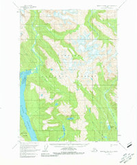
1955 Map of Bradfield canal B-6
USGS Topo · Published 1981About this map
Nelson Glacier feeds the headwaters of Aaron Creek within the southeastern reaches of the Tongass National Forest. This mid-century survey illustrates a dynamic glacial landscape where coastal channels meet high peaks, such as Berg Mtn. The hydrology is defined by a dense network of lakes and waterways, including Marten Lake and Upper Marten Lake, which drain toward the saltwater. Along the western edge, Blake Channel separates the mainland from the northern tip of Wrangell Island. The map records specific coastal landmarks like the Tidal Flat and Capel Pt, providing a detailed look at the maritime and mountain interface before significant modern development altered these remote drainages. Smaller interior water bodies like Full Lake and Campbell Lake are situated near the Harding River, tracing a complex system of drainage in the high country.
Find a feature on this map
20 named features on this map. Tap any name to fly to it.
Don’t see what you’re looking for? This feature index may not catch every label — zoom into the map to look around manually.
Map Details
Editions of this 1955 Bradfield canal B-6 Map
3 editions found

Other maps of this area

1948 · Petersburg A-1
USGS Topo · 1:63,360

1948 · Petersburg C-1
USGS Topo · 1:63,360

1948 · Petersburg B-1
USGS Topo · 1:63,360

1951 · Bradfield Canal
USGS Topo · 1:250,000

1951 · Petersburg A-1
USGS Topo · 1:63,360

1952 · Petersburg
USGS Topo · 1:250,000

1953 · Petersburg C-1
USGS Topo · 1:63,360

1954 · Bradfield Canal
USGS Topo · 1:250,000

1955 · Bradfield canal A-6
USGS Topo · 1:63,360

1955 · Bradfield canal B-5
USGS Topo · 1:63,360