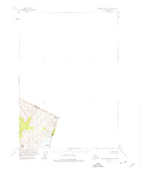
1955 Map of Bradfield canal D-6
USGS Topo · Published 1974About this map
Tongass National Forest dominates this high-altitude borderlands area where the United States-Canada boundary follows the jagged peaks of the Coast Mountains. The map illustrates a remote wilderness defined by steep glaciated terrain and the international divide, which separates Alaska from British Columbia. Mapping this rugged boundary required specialized control points, noted here as Mt Talbot and Mt Gallatin, which served as critical triangulation stations for surveyors. Below these peaks, the Tasekili River provides a primary drainage corridor. This sheet offers a meticulous record of the mid-century topographic effort to delineate the boundary in one of the continent's most challenging landscapes, where the absence of roads or permanent settlements highlights the extreme isolation of the region.
Find a feature on this map
6 named features on this map. Tap any name to fly to it.
Don’t see what you’re looking for? This feature index may not catch every label — zoom into the map to look around manually.
Map Details
Editions of this 1955 Bradfield canal D-6 Map
2 editions found
Other maps of this area

1948 · Petersburg C-1
USGS Topo · 1:63,360

1951 · Bradfield Canal
USGS Topo · 1:250,000

1952 · Petersburg
USGS Topo · 1:250,000

1952 · Sumdum
USGS Topo · 1:250,000

1953 · Petersburg C-1
USGS Topo · 1:63,360

1954 · Bradfield Canal
USGS Topo · 1:250,000

1955 · Bradfield canal D-6
USGS Topo · 1:63,360

1955 · Bradfield canal C-6
USGS Topo · 1:63,360
1955 · Bradfield Canal C-5
USGS Topo · 1:63,360

1955 · Bradfield Canal
USGS Topo · 1:250,000