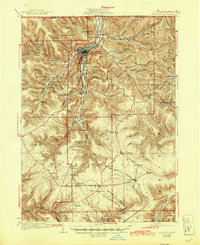
1926 Map of Bradford
USGS Topo · Published 1945About this map
Bradford serves as the industrial and transit hub of this McKean County landscape, situated at the confluence of the West Branch Tuna Creek and East Branch Tuna Creek. The mapping reveals a dense network of extraction and production infrastructure, including the Nusbaum Chemical Plant and Hazelton Mills, alongside smaller settlements like Derrick City and Sawyer City. This era was defined by intensive rail activity, with lines for the Erie Railroad, Pennsylvania Railroad, and Buffalo Rochester And Pittsburgh Railroad threading through the narrow valleys to serve the region's oil and timber interests.
Find a feature on this map
111 named features on this map. Tap any name to fly to it.
Don’t see what you’re looking for? This feature index may not catch every label — zoom into the map to look around manually.
Map Details
Editions of this 1926 Bradford Map
4 editions found
Other maps of this area

1898 · Olean
USGS Topo · 1:62,500

1900 · Salamanca
USGS Topo · 1:62,500

1922 · Randolph
USGS Topo · 1:62,500

1923 · Randolph
USGS Topo · 1:62,500

1924 · Bradford
USGS Topo · 1:62,500

1926 · Bradford
USGS Topo · 1:62,500

1933 · Smethport
USGS Topo · 1:62,500

1934 · Kane
USGS Topo · 1:48,000

1935 · Mt. Jewett
USGS Topo · 1:48,000

1936 · Kinzua
USGS Topo · 1:48,000