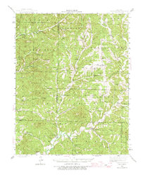
1943 Map of Bradleyville
USGS Topo · Published 1975About this map
Beaver Creek and its many winding tributaries like Little Beaver Creek and Caddo Creek define the settlement pattern of this mid-century Missouri landscape. The area is characterized by an extensive network of small rural school districts and family-named cemeteries, reflecting a period of localized community life before the widespread consolidation of services. Notable landmarks include the Swan Lookout and Jackson Mill, while the central settlement of Bradleyville serves as a focal point in the southern portion of the survey. The presence of descriptively named terrain features like High Lonesome Sch and Tater Hill speaks to the isolated, high-ground placement of early structures. This map documents the rural Ozark geography at a time when small communities like Brownbranch, Goodhope, and Arden were connected by winding ridge roads and valley trails, just as State Route 76 was beginning to provide more modern access through the region.
Find a feature on this map
90 named features on this map. Tap any name to fly to it.
Don’t see what you’re looking for? This feature index may not catch every label — zoom into the map to look around manually.
Map Details
Editions of this 1943 Bradleyville Map
2 editions found

Other maps of this area

1884 · Springfield
USGS Topo · 1:125,000

1886 · Springfield
USGS Topo · 1:125,000

1907 · Forsyth
USGS Topo · 1:125,000

1936 · Thornfield
USGS Topo · 1:48,000

1936 · Ava
USGS Topo · 1:48,000

1937 · Bradleyville
USGS Topo · 1:48,000

1937 · Ozark
USGS Topo · 1:48,000

1939 · Fordland
USGS Topo · 1:62,500

1942 · Fordland
USGS Topo · 1:62,500

1942 · Ava
USGS Topo · 1:62,500