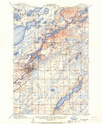
1915 Map of Brainerd
USGS Topo · Published 1967About this map
The Mississippi River winds through the heart of Crow Wing County, anchoring the regional hub of Brainerd during a period of significant rail-driven growth. Surveyed in 1914 and 1915, this map captures the dense network of rural infrastructure supporting the outlying townships of Maple Grove and Oak Lawn. A staggering number of numbered country schoolhouses, such as School No 57 and School No 4, are scattered across the landscape, marking the established rural communities of the era. The presence of the Minnesota Northern Pacific railroad connects the primary settlement with smaller outposts like Merrifield, Riverton, and Barrows. Extensive glacial water bodies, including the sprawling Long Lake and Lake Edward, dominate the northern and eastern portions of the quadrangle, illustrating the complex hydrology that influenced early settlement patterns and transport routes before modern highway development.
Find a feature on this map
63 named features on this map. Tap any name to fly to it.
Don’t see what you’re looking for? This feature index may not catch every label — zoom into the map to look around manually.
Map Details
Editions of this 1915 Brainerd Map
2 editions found
Other maps of this area

1912 · Deerwood
USGS Topo · 1:62,500

1913 · Cuyuna
USGS Topo · 1:62,500

1914 · Deerwood
USGS Topo · 1:62,500

1915 · Cuyuna
USGS Topo · 1:62,500

1915 · Brainerd
USGS Topo · 1:62,500

1916 · Pillager
USGS Topo · 1:62,500

1918 · Brainerd
USGS Topo · 1:62,500

1919 · Pillager
USGS Topo · 1:62,500

1948 · Belle Prairie
USGS Topo · 1:62,500

1948 · Lastrup
USGS Topo · 1:62,500