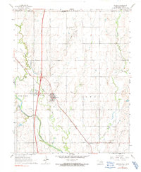
1967 Map of Braman
USGS Topo · Published 1991About this map
Braman serves as the central hub of this north-central Oklahoma landscape, situated just south of the Kansas border where the Chikaskia River and Shoo Fly Creek converge. The town's grid is anchored by the Park school and is surrounded by the industrial footprint of the North Braman Oil Field and Braman Oil Field. This area demonstrates a mid-century energy landscape, with numerous Oil Wells peppered across the section lines and specialized infrastructure like the US 177 Interchange facilitating regional travel.
Find a feature on this map
23 named features on this map. Tap any name to fly to it.
Don’t see what you’re looking for? This feature index may not catch every label — zoom into the map to look around manually.
Map Details
Editions of this 1967 Braman Map
2 editions found
Other maps of this area

1890 · Wellington
USGS Topo · 1:125,000

1955 · Wichita
USGS Topo · 1:250,000

1955 · Enid
USGS Topo · 1:250,000

1958 · Enid
USGS Topo · 1:250,000

1958 · Wichita
USGS Topo · 1:250,000

1965 · Portland
USGS Topo · 1:24,000

1965 · South Haven
USGS Topo · 1:24,000

1965 · Geuda Springs
USGS Topo · 1:24,000

1967 · Braman
USGS Topo · 1:24,000

1968 · Blackwell NW
USGS Topo · 1:24,000