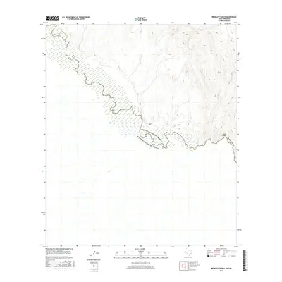
2016 Map of Bramlett Ranch
USGS Topo · Published 2016About this map
The Rio Grande serves as the central focal point of this borderland survey, marking the international boundary between United States of America and Estados Unidos de Mexico. The landscape is defined by the sharp transition from the river's floodplain into the arid topography of Hudspeth Co, where seasonal drainages like Squaw Cr cut through the terrain. Human activity is sparse, centered on the Bramlett Ranch near the riverbank. This proximity to the water highlights the long-standing reliance on the river as a source of life in the Chihuahuan Desert. To the east, the elevation rises into the complex landforms of Eagle Canyon, a distinctive geological feature that dominates the horizon above the river valley. The map provides a precise view of the geopolitical and physical interface where Texas meets Chihuahua.
Find a feature on this map
8 named features on this map. Tap any name to fly to it.
Don’t see what you’re looking for? This feature index may not catch every label — zoom into the map to look around manually.
Map Details
Editions of this 2016 Bramlett Ranch Map
This is the sole edition of this map. No revisions or reprints were ever made.
Other maps of this area

1892 · Chispa
USGS Topo · 1:125,000

1895 · Chispa
USGS Topo · 1:125,000

1897 · Eagle Mountain
USGS Topo · 1:125,000

1897 · Chispa
USGS Topo · 1:125,000

1916 · Eagle Mountain
USGS Topo · 1:125,000

1959 · Marfa
USGS Topo · 1:250,000

1965 · Marfa
USGS Topo · 1:250,000
1972 · Lobo SW
USGS Topo · 1:24,000
1972 · Bramlett Ranch
USGS Topo · 1:24,000
1972 · Mesquite Spring
USGS Topo · 1:24,000