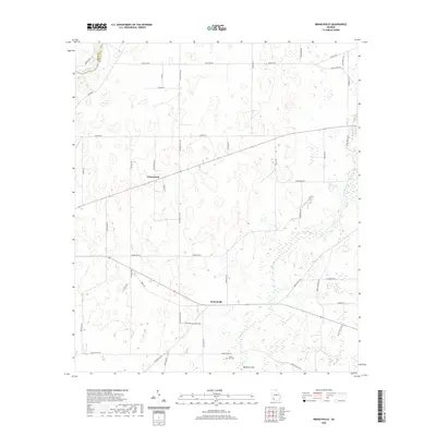
2020 Map of Branchville
USGS Topo · Published 2020About this map
Branchville and Greenwood anchor this survey of the Georgia coastal plain, where the landscape is defined by the transition from riverine systems to subterranean drainage. The Flint River marks the northwestern corner of the map, flowing along the Baker Co and Mitchell Co border. Further south, the geology shift is evident at Medicine Sink, a distinctive karst feature that illustrates the unique hydrology of this region. Local history is grounded in sites like the Turkey Pen Cem, which serves as a vital touchstone for genealogists and researchers tracing family roots in this rural portion of Mitchell County. The map details a network of country roads and drainage patterns that have shaped the agricultural development and community placement in the area.
Find a feature on this map
7 named features on this map. Tap any name to fly to it.
Don’t see what you’re looking for? This feature index may not catch every label — zoom into the map to look around manually.
Map Details
Editions of this 2020 Branchville Map
This is the sole edition of this map. No revisions or reprints were ever made.
Other maps of this area

1953 · Dothan
USGS Topo · 1:250,000

1954 · Dothan
USGS Topo · 1:250,000

1955 · Dothan
USGS Topo · 1:250,000

1956 · Baconton
USGS Topo · 1:62,500

1956 · Newton
USGS Topo · 1:62,500

1971 · Gee Pond
USGS Topo · 1:24,000

1971 · Vada
USGS Topo · 1:24,000

1971 · Camilla
USGS Topo · 1:24,000
1971 · Pelham
USGS Topo · 1:24,000

1971 · Hopeful
USGS Topo · 1:24,000