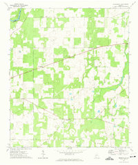
1971 Map of Branchville
USGS Topo · Published 1974About this map
The Flint River forms the northwestern boundary of this Mitchell County landscape, where the flat coastal plain is marked by distinctive karst features like Medicine Sink. In the early 1970s, the rural character of the region was defined by scattered agrarian settlements and small community centers. Branchville and Greenwood serve as primary points of orientation, while several country churches including Mt Zion Ch, Oak Grove Ch, Evergreen Ch, and Antioch Ch dot the road network.
Find a feature on this map
13 named features on this map. Tap any name to fly to it.
Don’t see what you’re looking for? This feature index may not catch every label — zoom into the map to look around manually.
Map Details
Editions of this 1971 Branchville Map
This is the sole edition of this map. No revisions or reprints were ever made.
Other maps of this area

1953 · Dothan
USGS Topo · 1:250,000

1954 · Dothan
USGS Topo · 1:250,000

1955 · Dothan
USGS Topo · 1:250,000

1956 · Baconton
USGS Topo · 1:62,500

1956 · Newton
USGS Topo · 1:62,500

1971 · Gee Pond
USGS Topo · 1:24,000

1971 · Vada
USGS Topo · 1:24,000

1971 · Camilla
USGS Topo · 1:24,000
1971 · Pelham
USGS Topo · 1:24,000

1971 · Hopeful
USGS Topo · 1:24,000