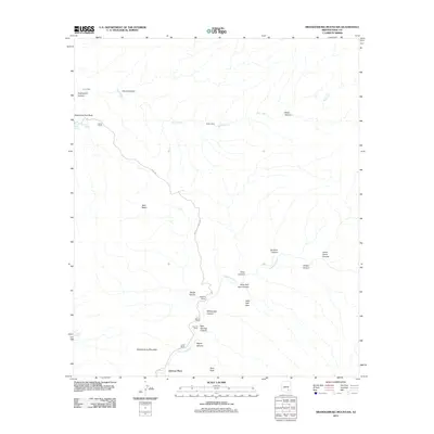
2011 Map of Brandenburg Mountain
USGS Topo · Published 2011About this map
Hortons Place and a network of remote ranching outposts define this high-desert landscape in Pinal County. This 2011 survey documents the established cattle-raising infrastructure of the region, anchored by the Wagner Ranch, Woods Ranch, and LaJolla Ranch situated along the drainage of Aravaipa Creek. The terrain is characterized by a series of steep drainages including Buzan Canyon and Hells Half Acre Canyon, which descend from the slopes of Brandenburg Mountain. Historical markers of land use are visible through features like Cedar Corral and seasonal camps such as Lion Camp and Apsey Camp. Natural springs like Burro Water Spring and Carrico Spring represent the critical water sources that made settlement possible in these canyons. The presence of Eskiminzin Fort Rock suggests the deeper cultural history of the area, while names like Virgus Canyon and Hagen Canyon reflect the individual families who worked this portion of the Arizona backcountry.
Find a feature on this map
32 named features on this map. Tap any name to fly to it.
Don’t see what you’re looking for? This feature index may not catch every label — zoom into the map to look around manually.
Map Details
Editions of this 2011 Brandenburg Mountain Map
This is the sole edition of this map. No revisions or reprints were ever made.
Other maps of this area

1911 · Winkelman
USGS Topo · 1:125,000

1913 · Winkelman
USGS Topo · 1:125,000

1915 · Christmas
USGS Topo · 1:62,500

1917 · Christmas
USGS Topo · 1:62,500

1938 · Klondyke
USGS Topo · 1:48,000

1943 · Klondyke
USGS Topo · 1:62,500

1949 · Holy Joe Peak
USGS Topo · 1:62,500

1949 · Saddle Mtn.
USGS Topo · 1:24,000

1949 · Brandenburg Mtn
USGS Topo · 1:24,000
1949 · Holy Joe Peak
USGS Topo · 1:24,000