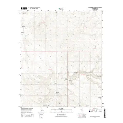
2014 Map of Brandenburg Mountain
USGS Topo · Published 2014About this map
Hortons Place and the surrounding high desert canyonlands are defined by a complex drainage system feeding into the Aravaipa Cr. This 2014 survey documents a landscape of dramatic vertical relief, where several springs such as Eskiminzin Spring and Burro Water Spring provide vital water sources in an otherwise arid environment. The presence of Eskiminzin Fort Rock suggests a history of strategic importance in the local terrain, overlooking a network of deep-cut features like Devils Canyon and Hells Half Acre Canyon. To the south, the massive bulk of Brandenburg Mountain dominates the horizon above Brandenburg Wash. The map details the remote transition from the high ridges of Periz Peak down to the riparian corridors of Aravaipa Canyon, accessible via the solitary E Aravaipa Rd.
Find a feature on this map
32 named features on this map. Tap any name to fly to it.
Don’t see what you’re looking for? This feature index may not catch every label — zoom into the map to look around manually.
Map Details
Editions of this 2014 Brandenburg Mountain Map
This is the sole edition of this map. No revisions or reprints were ever made.
Other maps of this area

1911 · Winkelman
USGS Topo · 1:125,000

1913 · Winkelman
USGS Topo · 1:125,000

1915 · Christmas
USGS Topo · 1:62,500

1917 · Christmas
USGS Topo · 1:62,500

1938 · Klondyke
USGS Topo · 1:48,000

1943 · Klondyke
USGS Topo · 1:62,500

1949 · Holy Joe Peak
USGS Topo · 1:62,500

1949 · Saddle Mtn.
USGS Topo · 1:24,000

1949 · Brandenburg Mtn
USGS Topo · 1:24,000
1949 · Holy Joe Peak
USGS Topo · 1:24,000