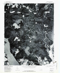
1978 Map of Brandon
USGS Topo · Published 1983About this map
The James River and Chickahominy River define this peninsula in Charles City County, where the landscape remained largely agricultural and wooded in the late 1970s. This orthophotoquad, produced in cooperation with the Soil Conservation Service, uses aerial photography to show the exact footprint of historic settlements like Brandon and Cherry Hall. The transition from riverfront marsh to upland fields is visible through the winding paths of Tomahund Creek and Morris Creek. Small rural crossroads like Rustic and Holdcroft anchor the inland areas, while Chickahominy Haven represents a more concentrated riverside development. For researchers, this photographic record provides an unfiltered view of field lines, woodlots, and homestead sites as they existed before modern land-use changes altered the James River waterfront.
Find a feature on this map
11 named features on this map. Tap any name to fly to it.
Don’t see what you’re looking for? This feature index may not catch every label — zoom into the map to look around manually.
Map Details
Editions of this 1978 Brandon Map
This is the sole edition of this map. No revisions or reprints were ever made.
Other maps of this area

1917 · Toano
USGS Topo · 1:62,500

1918 · Charles City
USGS Topo · 1:62,500

1918 · Toano
USGS Topo · 1:62,500

1919 · Surry
USGS Topo · 1:62,500

1919 · Disputanta
USGS Topo · 1:62,500

1943 · Savedge
USGS Topo · 1:31,680

1943 · Richmond
USGS Topo · 1:250,000

1949 · Richmond
USGS Topo · 1:250,000
1952 · Brandon
USGS Topo · 1:24,000
1952 · Norge
USGS Topo · 1:24,000